Greetings to all.
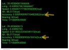
I am developing an application that requires maximum gps accuracy so I display this value on the screen. My problem is the following: when starting the gps the precision is improving until it reaches the value 3.9 m and from there it does not go down. The coordinate values are correct since I verify them simultaneously with another program, but the accuracy is not updated correctly.
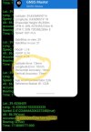
In the image you can see that the gps has an accuracy of 1 cm but it is not reflected in the library value.

Occasionally and without knowing the reason, the two programs do give the same accuracy, but after a few seconds it returns to show an accuracy of 3.9m.

I have also tried the FusedLocationProviderGNSS library and it works a little better, but after a while it gives the same error again.
I have tried with different devices and I use api33.
Is there any way to solve this error? What is the best way to have a position with maximum precision (to draw it on a map)?
Thanks to all.
I am developing an application that requires maximum gps accuracy so I display this value on the screen. My problem is the following: when starting the gps the precision is improving until it reaches the value 3.9 m and from there it does not go down. The coordinate values are correct since I verify them simultaneously with another program, but the accuracy is not updated correctly.
In the image you can see that the gps has an accuracy of 1 cm but it is not reflected in the library value.

Occasionally and without knowing the reason, the two programs do give the same accuracy, but after a few seconds it returns to show an accuracy of 3.9m.

I have also tried the FusedLocationProviderGNSS library and it works a little better, but after a while it gives the same error again.
I have tried with different devices and I use api33.
Is there any way to solve this error? What is the best way to have a position with maximum precision (to draw it on a map)?
Thanks to all.
